Sunday, March 20, 2016

Bonus Site: Bull Hill (Mt. Toby south)

The forecast for this weekend looked daunting, with seasonally chilly temperatures and a possible nor’easter storm on Sunday or Monday. However, it didn't turn out that bad, and by the middle of this coming week it’s supposed to warm way up again. In honor of THAT forecast, here is a new bonus site. 

As a brief recap of previous bonus site posts: my guidebook Trail Running Western Massachusetts (click here to view the book's page on Amazon) profiles 51 of the best trail running sites in the region. It was a challenge to whittle down the final list included in the book to just 51 sites, and some that I really like or that would have been nice to include had to get cut for space. I occasionally post profiles of some of those "bonus sites" here and link to them from the book's Facebook page. (see the Chapel Brook to D.A.R. Trail, Mormon Hollow, and Ashley Pond posts for previous examples).

Land ownership at this southern end of the Mt. Toby block is a complex puzzle of parcels, some of which are public conservation land with public access, some of which are private conservation land with public access, some of which are private land posted with No Trespassing signs, and some of which are unposted private land.  Trail signage is minimal, and restricted to the trailhead for the Robert Frost Trail and several major junctions along its route north to Mt. Toby.

There are some fun sections of trail, most notably the Robert Frost Trail as it gradually climbs up and over Bull Hill via Russell Hill from the trailhead at Bull Hill Road. There is also an interesting loop that can be made through The Nature Conservancy’s Greene Swamp Preserve, which includes two south-facing vistas with great views across the pastoral valley to the Holyoke Range and Mt. Tom beyond. Part of this loop traverses private land. 

autumn view from one of the south-facing vistas southwest of Bull Hill and Greene Swamp

hemlock ravine along Middle Mtn. Road
scenic hemlock ravine along Middle Mtn. Road on the west side of Mt. Toby

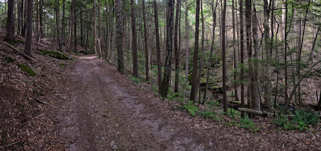
To the northwest, several dirt roads lead up from the town of Sunderland and head east toward Mt. Toby. There are several pretty stretches, including one notably pretty hemlock ravine, but for the most part these old roads (Middle Mountain Road and South Mountain Road) are heavily eroded and not particularly nice to run on since they are too full of loose rocks and wet, sloppy sections to be much fun. Also, a warren of unmarked trails and old roads weaves in and out of private land, some of which is distinctly posted No Trespassing. A better bet is to continues N/NE of the RFT toward Mt. Toby (see site #33 in the book). Note: the RFT Bypass Trail makes a particularly pleasant alternate option to the part of the RFT that runs just west of the summit of Roaring Mtn. (also, the hard-to-follow spur up to the wooded summit of Roaring isn’t really worth it).

Bull Hill (Mt. Toby south) -- Click here for a full-size pdf of the map

Other good nearby trail running sites: Mt. Toby, Puffers Pond and the Eastman Brook Conservation Area, Sugarloaf Mountain, Pocumtuck Ridge

If you have any comments, complaints, corrections, praise, or suggestions about this bonus site or anything related to Trail Running Western Massachusetts, please comment below or drop me an email with your thoughts!

Friday, March 18, 2016

many hats / heavy rotation

When people ask me what I do, I always struggle a bit to answer. I wear a lot of hats. In the past I spent a lot of time as a GIS Specialist in the environmental field, specifically focused on rare species and biodiversity conservation. Now, though, my current day job is working as a Production Editor (proofreading, copyediting, etc.) at the Pioneer Valley branch of a big multinational education company. My side gigs include being a photographer at Ben Kimball Photography (formerly Northeast Race Photo), author/salesman of Trail Running Western Massachusetts (and hopefully some sequel/companion guidebooks soon!), contract editing and proofreading for various clients, GIS mapping project work for various clients, and writing occasional articles for publications. And I'm also the editor of my local running club's newsletter, which comes out every two months and feels (in a good way) a bit like a full-fledged local running magazine sometimes.

This month, I had articles published in New England Runner and Level Renner magazines, and here is a link to the latest issue of the newsletter. It's all a bit exhausting, and at the same time I'm doing some intensive physical therapy for my achilles and trying to cross-train as much as possible on my bike (which has been easier than expected this month due to the near-complete absence of late-winter weather). But I'm feeling good, and I actually LIKE having so much variety and spinning so many plates and wearing so many hats, even though most of that "variety" somehow revolves around writing and running. I'm in a building phase. The trick now will be to keep momentum going on all fronts. Onwards!

 
L: the SMAC club profile in the March/April 2016 issue of Level Renner
R: an ad for Trail Running Western Massachusetts that ran in New England Runner

MDI Scenic Stridings article from the March/April issue of New England Runner

Monday, March 14, 2016

two trail maintenance days

This past weekend I participated in two local trail maintenance events:

Mt. Warner -- Gravelcrafting
On Friday, March 11, about a dozen people helped improve a frequently flooded section of trail at the Trustees' Mt. Warner reservation in Hadley, MA (see the Trustees' website for this site here). Starting at 9 a.m., we first had to spread some gravel and lay down medium-size sticks along a very muddy section of the right-of-way access road on an adjacent parcel at the northern end of the site, to ensure that the truck carrying the gravel could get up there. Then the truck dumped load after load of gravel (about one per hour) at the wet spot where we spent the next few hours working. First we spread the gravel out along and across the road using rakes and shovels, then made sure it was level or, in some spots, raised just slightly on uphill side for drainage. We also dug a decent-sized ditch on the downhill side of the road to allow for future drainage to be shunted away into an adjacent flat area where it could spread out and soak in and/or run down the nearby slope.

some photos from this work day
digging the drainage ditch

improving the trench

dumping gravel

spreading gravel

the finished section

Mineral Hills Conservation Area -- Spring Trail Work Day
On Saturday, March 12, about 20 people showed up to work on the trails at this site (see map), which is site #38 in my Trail Running Western Massachusetts guidebook. We split into several groups and headed to different areas. One group headed out with chainsaws to get rid of blowdowns. Another group went out to repair boardwalks. And a third went out to trim back shrubs and new growth. A fourth group, the one I was in, went up to the parking area at the upper end of Turkey Hill Road and cleared overgrown sections of the unnamed road/trail south of Stagecoach Trail, from the parking area up to its junction(s) with Stagecoach. Then I worked alone on the westernmost spur path leading up from a 4-way junction along Stagecoach to the southwestern corner of the quarry, mostly trimming shrubs, briars, and saplings, and leveling a few lumpy spots. And I also trimmed back a bunch of stuff growing out into the trail along the southwestern arc of the quarry loop trail, up to the new link trail that leads over to the Summit Trail. Afterwards, I also did a little bit of pricker and sapling trimming at the Sylvester Road parking area / trailhead sign kiosk.
(see the site's Facebook page for more details).

the quarry at Mineral Hills, looking north

After both days, my arms and neck were sore and skin on my keyboard-soft hands got rubbed a bit raw (I write and edit and make computer maps, and run and bike, so my hands are pretty wussy), but it feels really good to have given back a little bit and helped to maintain runnable/hike-able trails at some of the sites I enjoy frequently.

Wednesday, March 2, 2016

The Latest Sun

Two months ago I wrote a brief blog post about becoming the new editor of the Sugarloaf Mountain Athletic Club's (SMAC's) newsletter, The Sugarloaf Sun (or sometimes just The Sun). Somehow two months have flown by and the next issue is out already. Here's a preview of the cover, and a link to the full pdf on the SMAC website. I'm really proud of how this issue came out; the submissions from various club authors, creators, and runners were really terrific, and the volume was such that this ended up being a genuine double-sized issue. That said, I'm really looking forward to the next one (hopefully) being just a regular-sized issue. It's a lot of work putting it all together!

March/April 2016 issue of The Sugarloaf Sun