
Tuesday, May 28, 2013
Running in the Berkshires 2
Another weekend, another big race photo shoot in the Berkshires followed by a fun mid-distance trail run. This time the race in question was actually three-in-one: the marathon, half-marathon, and 10K events of the annual Memorial Day Marathon Races in Lenox (there was also a 5K but the route didn't pass by my location near Stockbridge Bowl). The weather was ferocious for a marathon on Memorial Day in New England. There were decent temperatures (50s) and on-and-off drizzle (fine for a runner) but also a very strong wind that made it seem much, much colder. Hundreds of runners persevered without complaint, however, and demonstrated plenty of the grit and determination you have to have to be a distance runner.

For my own running, it was a pretty sweet weekend (though only one of the three runs qualifies as "in the Berkshires"). I got a new 10K PR time (42:23) in chilly temps and light rain at the VFW-SMAC Memorial Day 10K in South Deerfield on Saturday. I completely owned the half-mile hill to mile 2 and felt great the whole way. After the photo shoot on Sunday, I parked near the Appalachian Trail crossing of the Mass Pike (on Rte. 20) and did a 9-ish mile out-and-back run south on the AT to Goose Pond Road. It rained almost the whole way, but that just kept the bugs and holiday crowds at bay and I had a blast. There were two significant climbs of about a half-mile each, followed by corresponding descents, one mile-long stretch of mostly flat trail along Goose Pond that was fairly soggy, and a number of rolling miles traversing side-slopes. And finally, on Monday, Jen and I ran along the Pocumtuck Ridge Trail in Deerfield. We started along Hillside Road (where we parked for a North Sugarloaf Mtn. run a few weeks ago) and went north about 4 miles to Pocumtuck Rock and back. Along the way we met and shared some good conversation with Oliver from the 413 trail runners. On the return leg we opted to do the last bit on road since the stretch between Stage Road and Hillside Road has some steep pitches and two significant patches of poison ivy (for some reason I've become VERY prone to getting to PI in recent years and really don't want to get it again anytime soon). In the end, a 24-mile weekend, and I'm at my lightest weight in years (172); bring on the summer races...
Thursday, May 23, 2013
Running in the Berkshires
This past Sunday I took photographs of runners in the inaugural Steel Rail Half Marathon in the northern Berkshires. I'm so pleased with how the photos came out; the athletes look fantastic and I'm truly proud to add these shots to my portfolio.
The day was a long one. I got up early, drove north through Colrain to Bennnigton and made it to mile 5 of the Shires of Vermont Marathon. I'd actually planned to shoot at mile 4 but got stuck in a line of traffic that had formed (ironically) due to the marathon. Lesson learned: get up even earlier.
After taking photos of runners in that race, I zipped south down Route 7 to Adams, MA where I parked and set up near the finish of the half-marathon route. Over the course of the next hour and a half or so I moved up and down a half mile stretch of the Ashuwillticook Rail Trail. I caught the lead runners near the crossing of Main Street, moved north to catch a few near CJ's Pub, then back south a bit, and finally ended up at the finish line to catch the last few coming through. In the end I got photos of nearly everyone (missing only the occasional occluded runner in a large pack), and as I said before they came out great. I'm very happy with the results.
When it was all over and the awards were starting (along with the light rain that would continue for much of the afternoon), I set out for my own run. I went up the rail trail to Cheshire, and then got off onto the Appalachian Trail and ran up to Cheshire Cobbles where there was a spectacular view out across the valley towards Mt. Greylock. I managed to run the entire way up, which easily took about twice as long as the very fun descent.
On the way back to Amherst I drove through Savoy, a town I can't wait to get back to later in the summer for the trail race there. All in all a long, exhausting, and very rewarding day of running in the Berkshires.


Wednesday, May 22, 2013
Discovering Sugarloaf
I've lived in the Pioneer Valley for almost 2 full years now and have been a regular participant at local running races (and been a member of the excellent Sugarloaf Mountain Athletic Club), but I've only just recently discovered the fantastic running trails on North Sugarloaf Mountain. A few days ago, Jen, who used to run there years ago when she lived and worked close by, took me to her old stomping grounds. And I'm so glad she did! We parked at the tiny parking area off of Hillside Road (the one second-closest to River Road) and headed up the main trail from there.
There appears to be a small network of trails here, some official and some not. At present, there's no map to be found and no signs at the junctions and it seems like it could be a bit confusing, but it doesn't really matter. The place isn't THAT big and if you get lost running the worst that happens is you end up down on a road and have run several miles back to where you parked.


Anyway, we headed up a trail that zigzagged back and forth, nearly doubling back on itself several times in tight hairpin turns, looping and swooping and meandering for about a mile up to the trail that runs along the summit. It was spectacularly good running. Sort of like the mountain bike trails on the south side of the Holyoke Range only with more forgiving footing.

view from the summit ledges on North Sugarloaf Mountain
At the top there's a nice view to the west out over South Deerfield from a precipitous open rock outcrop. We took the trail south from there, immediately dropping down the south side of the hill towards South Sugarloaf Mountain. About a quarter mile down, we took a somewhat obscure left turn onto a trail that runs along the east side of the hill back towards Hillside Road. There are a few short ascents along the way, but mostly it's gradual descent.


All around, it was a very pleasant surprise, and I'm really surprised I haven't run there before given that it totally seems to be right in my wheelhouse. I'm psyched to go back and explore the other trails there, along with the Pocumtuck Ridge Trail that runs north from there (which I hear makes another good trail run).

running along the summit ridge
There appears to be a small network of trails here, some official and some not. At present, there's no map to be found and no signs at the junctions and it seems like it could be a bit confusing, but it doesn't really matter. The place isn't THAT big and if you get lost running the worst that happens is you end up down on a road and have run several miles back to where you parked.


view from the summit ledges on North Sugarloaf Mountain


running along the summit ridge
Tuesday, May 14, 2013
Wapack and Back
Had a great time taking photos at the Wapack and Back Trail Races this past Saturday. In the morning, I drove out to Wachusett Mountain in north-central Massachusetts to take photos of the hillclimb bike race (photo gallery here). I hiked up the auto road to the highest ski trail crossing and took shots of the "sufferfest" as riders gasped their way by (actually, most looked pretty spry still, and some even looked fantastic!). Then it was about a half-hour drive north to the trailhead for Mt. Watatic where I found the finish line for the trail race all set up and ready to reward runners.
The leaders wouldn't be there for a while yet, so I hiked out on the Wapack Trail towards the Binney Pond Road aid station. Bypassing the summit of Watatic to save a mile or so, I took the State Line Trail cutoff, which was actually quite nice, even if the various junctions were slightly hard to follow (they were signed, but they didn't exactly match the map I had printed out). After crossing the state line into southern New Hampshire, I met the lead runners of both the 50-mile race and the 21.5-mile race in the ultra-scenic clearcut area just south of the Binney Pond Road aid station.
It was a pleasure to meet and talk with TARC (Trail Animals Running Club) members Tim and Kristen who were staffing the aid station. They were set up with food, beverages, and rockin' tunes coming out of the truck. And there was a tarp over the table, which was particularly nice since it was lightly raining off and on throughout the day.
A little farther north I ran into Scott Livingston, a fellow trail runner/blogger/photographer dude who it was good to finally meet; no more pure blog lurking! He was coming back from just having hiked all the way out to Windblown. After a brief chat about photography we were on our ways again.
I took most of my runner photos in the next mile to the north, where the Wapack Trail passes through NH's Binney Pond State Forest. This is a very pretty stretch, and well worth a visit just to hike sometime. After skirting along the boggy edge of the shallow pond itself, the trail meanders through deciduous woods and then eventually climbs up 1,817 ft. high Pratt Mountain via a series of steep-but-not-too-steep switchbacks. At the top, there's a great southern view out over the pond to Watatic. Runners were pretty infrequent by this point (I'd been out on the trail for several hours), so after half an hour I headed back down.
A quick response to the runner who ran by and said "so these photos are going to be free, right?" Well... no, they're not. You wouldn't expect to walk into a record store and say to the owner "so these CDs are free, right?" My time is not free. The camera equipment wasn't free. Photos are my product. I love taking the pictures and I enjoy the whole process (and I sincerely hope the athletes I take photos of enjoy seeing themselves in action afterwards), but I need to eat and pay bills just like anyone else. To put it as simply as I can: if I don't sell any photos, there won't be any more photos, not from me anyway, because I won't be able to afford to take them.
Following a brief stop to wash poison ivy off my leg (I seem to have become a PI magnet in recent years), I made it back to the aid station just in time for the heavier rains to set in. I snapped a few more darkish shots of some of the later runners (either finishing the 21.5 or coming back out for the last 7 miles of the 50) and called it a day around 5PM. I'd hiked about 7 miles total.
Coda: After driving back west through heavy rain on Route 2, Jen and I met up in New Salem (the NEW Salem) on the northwestern edge of the Quabbin and ran the 6.2 mile course of the Rabbit Run, which will take place this coming Saturday. The skies cleared and we had an excellent, bug-free run in the late evening light. Then we topped the whole day off with beer, food, and live music at Deja Brew up in Wendell.


Binney Pond from the overlook on Pratt Mountain, with Mt. Watatic rising in the distance.


L: Runners descend Pratt Mountain; R: Best race moment ever.

Slaphappy trail racers at mile 48 or so.

Signs at the Route 119 trailhead for Watatic.
Monday, May 13, 2013
Arches East
Is Kentucky part of the South? I don't think so, not really. I mean clearly it's part of the Bible Belt, but geographically it's well to the north of south. Deep South, anyway. Is it part of the Northeast? Probably not. The Midwest? I don't know. Appalachia, for sure. But along with maybe Missouri, it's really kind of in the middle, refusing to be pigeonholed one way or the other. Regardless, I'm gonna write about it here at Northeast Adventures. Because I found something really neat there. Possibly peripheral, but plenty welcome.
Red River Gorge isn't really in a mountainous region of Kentucky. It's well to the west/northwest of the Blue Ridge and the rest of Appalachia. Or at least, it's at the western edge of the Appalachian foothills. What it IS, though, is a canyon. Or rather, a connected series of canyons. With vertiginous mesas and cliffs and arches. Like something you'd find out in Arizona or Utah, only vegetated. Arches East. How cool is THAT?!?


Special mention must be made of a highly entertaining radio station out of Morehead: Mix 106 ("The station no one can agree on at work" "Less Talk, More Head" "A bunch of songs that seem like they shouldn't go together, but strangely... do"). We listened to it all week. Still trying to see if I can stream it at home.
A few weeks back (in late April), Jen and I took a quick vacation trip to Red River Gorge in Kentucky. We flew into Charleston, West Virginia, rented a car, and drove a few hours west on I-64. After a brief stop for lunch in Huntington (I now get all the "We Are Marshall" references), we wound our way into eastern KY.
Red River Gorge isn't really in a mountainous region of Kentucky. It's well to the west/northwest of the Blue Ridge and the rest of Appalachia. Or at least, it's at the western edge of the Appalachian foothills. What it IS, though, is a canyon. Or rather, a connected series of canyons. With vertiginous mesas and cliffs and arches. Like something you'd find out in Arizona or Utah, only vegetated. Arches East. How cool is THAT?!?

panorama shot of the very popular Gray's Arch from beneath the rock shelter


L: Red River Gorge from Chimney Top rock. R: Expanse.

our ridiculously sweet cabin for the week (hot tub on deck and mid-week rates!)

wading out to Rock Bridge Arch

drizzly day wildflower walk

rich woods

solace cove


L: Suspension bridge over the Red River. R: A trailside iris.

stuff on the other side of Double Arch


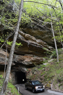
L: Nada Tunnel. R: Where's Jenny?

Below the span at Natural Bridge State Resort Park. Apparently, this is normally an insanely crowded place, complete with a chair lift to near the top of the arch. Not that we would have taken it anyway, but the chair lift was closed (it was drizzly off and on). We hiked up about a mile to get here and saw a grand total of two other people the entire afternoon. Jen is about to hike up through a slot called Fat Man's Squeeze.

Hanson's Point, where we found the finest view at Red River Gorge. The ridge dropped off on either side and ended at a remote ledge with 360-degree views of the canyon (our lunch spot for the day). This unofficial, unmarked spur trail was a few miles into a 9-mile loop hike.
Somehow we managed to time this trip just right. Apparently the place gets VERY crowded, but we were there mid-week and saw almost no one the entire time we were out hiking or exploring; it really seemed like we had the place to ourselves most of the time. Also, spring had just arrived and the leaves were coming out and wildflowers were going gangbusters, but the bugs weren't bad at all and it was perfectly pleasant in terms of temperature. And finally, because we were there mid-week, we got a significantly lower rate for our cabin.
Aside from the extremely cool arches and great hiking, we also enjoyed a few dinners out: local food and drinks at the Red River Rockhouse and laid back everything at the climber's paradise of Miguel's Pizza. Red River Gorge is a huge destination for rock climbing, and it often seems like you'll see everyone at either of these two excellent places at the end of the day.
Special mention must be made of a highly entertaining radio station out of Morehead: Mix 106 ("The station no one can agree on at work" "Less Talk, More Head" "A bunch of songs that seem like they shouldn't go together, but strangely... do"). We listened to it all week. Still trying to see if I can stream it at home.
Sunday, May 5, 2013
weekend update
On Saturday, I went up to Chesterfield, NH to take photos of the Chesterfield Fun Run 10K race. I'd worked out an issue I'd been having from time to time with the focus on my D600, and the shots came out beautifully. A gallery should be up within a day or so. Afterwards, I parked at the trailhead for Mt. Pisgah and Kilburn Pond, and went in to do a run on the infamous Kilburn Loop Trail; I'm giving serious consideration to doing my first ultra there later this year.
This morning I went to the base of Mt. Tom to take photos of the first few miles of the 51st Annual Walter Childs Memorial Race of Champions Marathon (note to race organizers: that is a seriously clunky long name! definitely at least consider shortening it some). After catching a bunch of shots of each runner (I'm very excited about how these turned out!), I zipped around across the river to catch the halfway point of the Seven Sisters Trail Race. After talking briefly with the volunteers at the halfway aid station, I hiked up about a quarter of a mile to a spot to take shots of the leaders coming through. Then I spent the better part of the next hour taking photos of runners descending the ledgy section in the powerline swath there. Again, I'm pretty psyched about how these shots came out! Anyway, after the final (or near-final) runners came though, I headed back over to the marathon to catch anyone finishing above a 3:30. It's a cruel finish, asking runners to climb for more than a mile to the end, under a beating sun with no shade. But the runners I saw looked fantastic. Strong, determined, and fit as hell.
Galleries will be posted for all three races later this week. And now... I get to go for another run!


L: My friend Patrick on his way to a marathon PR!
R: Cruising down to the turnaround at seven Sisters.
Weekend Update Update: Photo Galleries are now up for all three of these races!
Thursday, May 2, 2013
five more races (a.k.a. one busy week)
After getting back from a quick but excellent vacation trip to Red River Gorge in Kentucky last week (special blog post coming soon), I shot four local races this past weekend. And have spent the better part of this week madly processing and posting the shots. Also on the processing plate was finishing off photos from the recent Cave Hill Classic Fiver Miler in Leverett. Anyway, galleries are now up for all of these races:
Cave Hill Classic 5-miler Leverett, MA gallery
Annual Walk/Run to Remember 5K Northampton, MA gallery
Sheriff’s Sprint Pool Triathlon Ludlow, MA gallery
Daffodil 5K Fun Run Amherst, MA gallery
Quabbin Classic Road Race bike race Ware, MA gallery


Annual Walk/Run to Remember 5K Northampton, MA gallery
Sheriff’s Sprint Pool Triathlon Ludlow, MA gallery
Daffodil 5K Fun Run Amherst, MA gallery
Quabbin Classic Road Race bike race Ware, MA gallery

Coming though Rattlesnake Gutter at the Cave Hill Classic

Start of the Run to Remember 5K in Northampton

Hammering on the bike at the Sheriff’s Sprint Triathlon in Ludlow


Just past mile 2 at the Daffodil 5K Fun Run in Amherst

Quabbin Classic Road Race