
dropping down the south ridge of Gorham Mountain in Acadia
Once again, Jen and I took an August trip to Acadia to visit family and seek out fun summer adventures in the park (preferably away from crowds as much as possible). This visit was a super-abbreviated one because, although we planned to stay with my mother for a full week, Jen's 96-year-old great aunt out on the Cape was in her final days. Jen had been going out there to help take care of her for years, and this wasn't a surprise but it was a surprise that it happened just as our vacation started. Oh well, what are you gonna do. Anyway, the downshot was that we only had 3 days on the island. The upshot is that we made the most of it and really enjoyed ourselves while we were there.

Run 1: Mansell Mountain / Long Pond
On day 1 (August 6) we returned to a known fun section of trails on the western side of the island where we knew the crowds would be light. It turned out the crowds were REALLY light, and we had the Pine Hill parking area entirely to ourselves again.
we found a spot
We ran up the Great Notch Trail to the first junction, then turned left and descended Great Pond Trail to the western shore of Long Pond. The drop to the pond took longer than I remembered, and the footing was pretty rough at first. But it got more fun the lower we went, and by the time we were nearing the lake we were flying along in full stride down the delightfully soft trail, past mossy outcrops, and over occasional bridges and boardwalks. It was the middle of a heat wave and I melt in heat, so we stopped at one of the awesome ledges and I swam around in the lake for a bit. Then we continued south along the edge of the lake to the base of the Perpendicular Trail. After a brief wetting of our caps in the water, we took off up the talus slope and climbed the endless stone steps to the vista ledges a quarter mile or so below the top.

dropping down to the lake

dry boards

dry creek

swimming ledge

lakeside stroll

more lakeside stroll


climbing the Perpendicular Trail

most of the way up Mansell
From the ledge, we jogged up and over the top of Mansell Mountain and down to the Razorback Trail. At this point, we realized that it was really hot out, and we were both nearly out of water in our hydration packs even though we were only a few miles into the run. So we decided to abbreviate our run and head back to the car. Which was fine; we enjoyed ourselves and went for a nice cool-down swim in Somes Pond afterward.

Run 2: Ocean Drive at Dawn
On day 2 (Aug. 7), we got up before dawn (a miracle for me) and headed over to Ocean Drive to beat the heat and the crowds. We started our run from the empty parking lot at Fabri and did Ocean Drive in reverse to where the Shore Path starts on the southwest side of Otter Point. The sun rose over the ocean as we rounded Otter Point, and it was as majestic as we'd hoped. Up and over Otter Cliffs and then down and alongside Ocean Drive to Sand Beach, with a little side trip to Thunder Hole (which was doing nothing as the tide was all wrong at the time). One more climb and then a drop down to Sand Beach.


Sand Beach and The Beehive from Great Head


climbing The Beehive Trail


summit ledges of The Beehive

The Bowl, with Champlain Mountain behind it

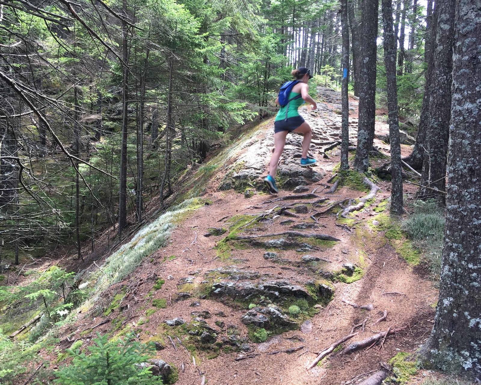
Gorham Mtn. summit

flying down Gorham Mountain
On the far side of Sand Beach I anticipated needing to cross the brook, but it was all dried up due to the drought. We climbed up Great Head and navigated the very rocky trail around the perimeter. The footing was tough but the scenery is so worth it. The heat was intense, though. The temps were already in the 80s and the humidity was so high the air itself seemed to be sopping wet even though it was sunny out. It was barely an hour into the day and we were sweating buckets.
Jen had never climbed either The Precipice or The Beehive, so I made the call that she really needed to at least do one of them, just... because. So up The Beehive Trail we went. The initial climb from Ocean Drive was slightly longer and steeper than I'd remembered, but we worked our way up and then started up the side of the mountain proper.
Now, I'd hiked both The Precipice and The Beehive many times in my youth. Not once do I remember ever actually being scared or anxious. It was always just thrilling and cool. And in the case of The Beehive, I had it in my head as the easy younger sibling of The Precipice. Well. I don't know if I just got older, or if it was the combination of our sweat and the gallons of slippery sunscreen that we'd slathered on and that was making our hands so slippery, but dang. The Beehive was kind of freaky! A few of the iron rung sections, and definitely the iron bridges, seemed especially vertiginous and dangerous. But eventually we reached the top and I could tell that Jen had quickly transitioned from fear to enjoyment, and she was already plotting our return visit on a drier day.
On the other side of the summit, we took a quick dip in The Bowl to cool off. Then we made our way over to Gorham Mountain for the final climb and ridge descent of the day. On the other side, we took the new-to-me spur trail west over to the Fabri road (this trail serves as a connector to Blackwoods Campground and keeps hikers off the busy road; a very nice new addition to the trail network).

Run 3: Loop of Great Notch Trail and the Razorback Trail
On day 3 we split our running into two parts. Part 1 was a return to Western Mountain because I wanted Jen to see the southern part of the Razorback Trail (which we had originally planned to include as part of our route on day 1). So we did a little 2+ mile loop starting and ending at the small and relatively remote Gilley Field parking area. We slowly climbed up the south end of the Great Notch Trail, then climbed to the top of Razorback and enjoyed the hell out of the super-scenic descent along the semi-open ridge. The only not-good part is at the very bottom where the trail is basically just a bunch of loose small boulders and cobbles.


descending the Razorback Trail
Part 2 was a loop at Flying Mountain. It had been a long time since I'd been there, and it seemed like a nice short trip that fit well in our day. It was very hot again, so we didn't want to be out long anyway. So we slowly climbed up the south side, took some photos at the top, and dropped down to Valley Cove on the north side. The descent was quite fun. Normally I find the ocean super cold at MDI, but man it was really hot out, so we stripped to our shorts (and jog bra for Jen) and took a quick dip in Valley Cove. Which felt fantastic! I'm not sure I'd ever actually swam there before. After splashing about and watching hermit crabs for a while, we eventually returned via the fire road trail through the notch between Flying Mtn. and St. Sauveur.

summit of Flying Mountain

approaching Valley Cove


Valley Cove panorama
And then we had to leave. Jen got word that her Great Aunt was probably in her final days out on Cape Cod and we made the decision to abandon our vacation early the next morning. We made the right call, as she passed away only a few days later, and Jen was there for it with her sister, as it should have been.

On our way back to western Massachusetts, we stopped in at my friend Molly's ice cream place just off the island in Ellsworth, to say hello and treat ourselves to some terrific treats. And about an hour later we drove straight into what really looked like a tornado on the highway near Newport (it was just a shelf cloud in a really powerful weather front that was moving through).


a real pulse-quickener


