Sunday, November 24, 2013

Running Notchview


Perched high up on a series of hills in the north-central Berkshires, TTOR’s Notchview Reservation is just a half-hour west from me on Rte. 9. I’ve known about it for a couple of years, and driven past many times now, especially since moving over to the western side of the valley, but have never had (or made, I suppose) the time to stop and check it out. So it felt like a long-overdue visit when, the other day, Jen and I threw on some warm clothes and headed up to do a trail run on some of the cross-country ski trails there.

[apologies to our fellow 413 Trail Runners for the last minute invite; we had such a blast at last week's 15-mile Movember Race on Mt. Tom and we wanted some of you guys to come along; we just came up with the idea pretty late in the morning.]

Not surprisingly, we were the only car in the expansive main lot. It was, after all, a 30-degree late-November afternoon with a stiff northwest wind blowing it. Before setting out, we poked into the Budd Visitor Center to use the bathroom. There we met Patty, a volunteer who was busy putting a finishing coat of fresh paint on some rooms upstairs. She offered lots of helpful information and advice, and would very quickly prove to be an excellent new friend. We also saw a map of a recent 10K held on the site tacked to a bulletin board. I traced the convoluted route it took on the map copy we’d brought, and we set off for our run (the network can be a bit confusing; check the property's website for a full trail map).

As soon as we stepped outside we were met with that northwest wind. Brrr… We decided to modify the early part of the run to cut out a short open field section in favor of a detour on the more sheltered Mixed Woods Trail. The footing was a bit rough on that trail, but the constant hummock hopping and low-stump dodging was actually kind of fun, especially since it wasn’t too leaf-covered and it was trending downhill. After that the going just got better and better. We climbed up through a different field and enjoyed the sunny exposure now that we were warmed up.

Our route took us along a variety of trails and terrain types. Bumpus Trail (made me think of Bumpus Brook up in the Whites), Skating Loop, and Minor Trail (which had some soggy sections). Somewhere around the Trela Shelter we bumped into Patty, out on the trails for her own run, and then we saw her again out on Shaw Road, where we joined her / she joined us for a few miles. We took another slight detour off of the 10K course, this time to climb up through a spectacularly scenic semi-open field high up on a hillside with amazing views to the south and east. Then we got on the Minor Trail again for some gradual climbing, said goodbye to Patty at junction 13 (she was off to do a tougher hill workout somewhere), and then took the somewhat rough Windsor Trail back to Shaw Road.

By far my favorite area of the day was the next mile or so, where the grassy Circuit Trail goes up and over a spruce-covered hilltop, with smaller but appealing side trails intersecting at frequent intervals (the mossy Bridge Trail looked particularly inviting). We paused to take several photos until we began to chill down and realized that, yeah, it was still 30 degrees and windy out. Back down to Trela, hard right on Circuit, and a final short ascent up and over Spruce Hill. Coming back out into the main field, we ran our last steps of the day heading into the setting sun to the southwest. An excellent workout on some very well-maintained trails at a place that definitely just became a new favorite. 

Jen sets off into the woods

leaper! (it looks a little bit like I'm wearing clown shoes in this shot)

Climbing up through Bates Field with Patty

The view from Bates Field

Circuit Trail

trail along a mossy hilltop

coming back out into the main field

journey's end

Chapel Brook to DAR Trail


A few weeks back I posted a quick trip report about exploring the Two Bridges Trail that connects two properties owned by the Trustees of Reservations (TTOR), the Chapel Brook Reservation in Ashfield, MA and the Bullitt Reservation (an airborne Steve McQueen at the wheel comes to mind every time) in Conway, MA. Since I'm new to the neighborhood, it was unexplored territory, and I was really pleased to find that the trail was very well laid out and marked, and that it was more geographically and ecologically interesting than I'd expected. I had a great run all around. This week I went back to explore the other side of the road.

From the parking lot along the Ashfield/Williamsburg Rd, a wide doubletrack trail leads up the slope to the west and soon arrives at a junction at large sign below Chapel Ledges on Pony Mountain. A set of wooden steps cut into the hillside leads up to the base of the ledges that apparently are very popular with rock climbers (it's easy to see why). From the base of the ledges you can take either leg of a loop trail that goes to the summit. I went straight up the steeper part, which ascends along the base of the ledges via a series of impressively constructed log cribs. Near the top, a spur path leads up to the actual top of the knob. The true summit is mostly forested, but the tops of the steep ledges are open and there are pretty sweet views to the southwest from there. I ran the loop back down around to the base of the hill, taking it east as occasional loose rocks were totally obscured by a thick duff of fallen leaves.

Back at the big sign, I took the barely noticeable (due to fallen leaves) singletrack trail southwest towards the D.A.R. State Forest. At present, this trail is saddled with the painfully unwieldy name of "Chapel Brook Reservation to D.A.R. State Forest Trail" (ouch). Let's hope it gets a more concise name soon! Labeling aside, I have to give major props to the people who made this trail happen. I think it was a collaboration of the Town of Ashfield with TTOR and the Franklin Land Trust. At least that's what I learned from a now-deleted document on the Town of Ashfield's website. Anyway, the point is, this is a really sweet trail, and it made for another great run in the area.

Heading west from the sign, the trail gently rises and falls towards D.A.R. State Forest several miles away. It passes by several rustic wooden benches, crosses a couple of scenic streams, skirts a pond, and comes close to two old stone foundations. It's all very runnable, and it wasn't even as leaf-covered as other trails in the area have been lately. It was a real pleasure to do an out-and-back on this trail, and I can't wait to come back in the spring to string it together with the Two Bridges Trail and a large loop at DAR for a nice long, scenic, and fun trail run.

L: start of the trail to the base of Chapel Ledges
R: rustic cedar bench along the Chapel/DAR Trail, with Pony Mtn. in the background

southwestern view at the top of Chapel Ledges

 forested hillside just to the west of Pony Mtn.

bridge and swooping trail about 0.1 miles west of the ledges

crossing Chapel Brook about 0.5 miles west of Pony Mtn.

***
UPDATE (11/29/13)
***

I went back about a week later and took these photos while doing a longer, lollipop loop run using this trail and the Moose Run Trail at DAR State Forest (7 miles total). 

sundown along the Moose Run Trail at DAR State Forest

L: One of many low bridgeways along the upper end of the Chapel Brook / DAR Trail
R: rustic pondside bench near DAR State Forest

Thursday, November 14, 2013

leapers

a rare double-leap at the Ghost Run Half-Marathon in Hebron, CT

I've been photographing at races for nearly a year now, and here's a fun little phenomenon I've had the pleasure of observing more than a few times: the leap. At first I was only seeing it in ultras, so in my head I started calling it the Ultra Leap. But I've since witnessed it at several trail races as well, and even in the occasional half-marathon and 10K too. So now my question is, does anybody know whether the leap is anything more than just spontaneous moments of athletic exuberance, or did I maybe miss a meme somewhere? Please let me know your thoughts! Whatever the inspiration, I have to say it totally makes my day when it happens. So, the next time you see me (tall, skinny, doofusy-looking guy with a camera) taking your photo at a race... consider trying a leap; it's always fun and I'd love to see more!

leaper at the Cider Donut Run 10K in Amherst, MA

 1.2.

3.4.
leapers at 
1. Hancock Shaker Village 50-Mile Ultra in Pittsfield, MA
2. Firecracker Four-Miler in Brattleboro, VT
3. Mt. Toby Trail Run in Sunderland, MA

Karna's SECOND leap, well into the Hancock Shaker Village 50-Mile Ultra in Pittsfield, MA

leaper at mile 47 of the Vermont 100 ultramarathon in Reading, VT

Wednesday, November 13, 2013

Seven Sisters Run

A few weeks back, Jen and I took a trip up to the Holyoke Range and ran a one-way traverse of the Seven Sisters Trail Race course, a roughly 6 mile run from The Notch to the M-M trailhead on Mountain Rd. We'd both hiked the section before, and I've photographed the trail race in May of both 2012 and 2013, and we've each run and snowshoed portions of the course many times, but neither of us had either actually run the race or run the route point to point like that.

The challenging terrain of this run is what usually sets it apart from others (and is part of the appeal), but on this day it was the season that stood out the most. A late-fall chill called for long-sleeve shirts and gloves, with a stiff breeze making us move on quickly from all the scenic overlooks. I'm sure on some summer days the heat would be brutal, but this time we needed to keep moving just to stay warm. Also, since most of the leaves had already come down the footing was especially tricky and you never knew what would be underfoot with any given step. Nevertheless, we were determined to give this run a try.

While no part of the run posed too much of a challenge, and we only slowed to a hiking pace up the steepest sections, we still took our time and prioritized not rolling ankles over a fast pace. As a result, the trip ended up taking a lot longer than we thought it would. My pausing every few minutes to try to take pictures with the lightweight camera I was carrying probably didn't help. The fallen leaves were particularly treacherous, even when dry. I slipped once on a ledge early on and scraped up a leg, and many stretches required extremely slow going just to make sure our feet didn't end up jammed into hidden crevices.

In the end, I'd have to say neither of us feels particularly compelled to sign up for the 2014 Seven Sisters trail race. While we love trail running and don't shy away from tough courses or routes, this one just seems like it would be unpleasant. We've each got weak ankles and I bet it's a rare race around here that has more ankle-busting terrain than this one. Still, people seem to really love it. I'm sure if we actually did it we'd sing a different tune, but for the moment we're content to let others take the slots and risk the ankle rolls. I'm also sure that by next May I'll probably be first in line to race =)

Mt. Holyoke Range State Park sign at The Notch
 in the Notch (lots of recent road improvements here)

climbing the talus slope on the west side of Bare Mtn.
Jen heads up the talus slope on the west side of Bare Mtn.

the view from Mt. Hitchcock in the Holyoke Range
the view from Mt. Hitchcock (mostly cloaked in cloudshadow at the moment)

M-M Trail over the Seven Sisters in the Holyoke Range
Jen rounds one of the middle Seven Sisters

scenic view in the Holyoke Range
looking west from the last of the Seven Sisters (one of my favorite views in the range)

M-M Trail at Taylor Notch in the Holyoke Range
 dropping down into Taylor Notch

the view from Mt. Holyoke

 overtopping outcrops

descending the final mile

Titan's Piazza in the Holyoke Range
Titan's Pizza (just off the trail near the turnaround, but well worth a look)

Saturday, November 9, 2013

Trying out the Two Bridges Trail

Earlier this week, in an effort to get to know my new neighborhood a bit better, I took a 10-minute drive up the road and parked at the Chapel Brook Reservation trailhead in Ashfield. The property is owned by the Trustees of Reservations (TTOR) and is a really amazing place. It's got a spectacular waterfall right near the road, miles of very nice hiking/running trails, glacial erratics, and scenic views from open ledges. For the full scoop, see TTOR's web page about it here.

The Two Bridges Trail instantly became a favorite new local trail run. It's a lollipop loop, approximately 4-5 miles total, with most of it consisting of out-and-back on the "stick" part. There are ups and downs for sure, but it's very runnable and it only has one short section steep enough that you probably need to hike (and even that section is nicely constructed with a series of zig-zag switchbacks up the slope).  

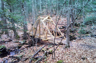
My route began and ended at Chapel Brook Falls. After a short descent on Chapel Falls Rd (an eroded dirt road, closed to traffic), the trail veers left and drops down through the woods to Chapel Brook, which it crosses via the eponymous two bridges. The bridges are new, and they are hearty. Clearly built to last. 

From the bridges, the trail climbs gradually along a feeder brook for a while. Then you reach the steep part, and climb the slope via a series of nice switchbacks. At the top, there's about a mile of easy running until you get to the start of the loop at the northern end. Well, "easy" in the sense that it's not very steep or anything, but all the recently fallen leaves and small cut stumps did make footing a little tricky in places. In general, though, this is a really pleasant trail to run on. It's also very well marked and easy to follow. 

The loop part passes by a big boulder (called the "pebble") wedged in between some trees, and then drops to a scenic view at the top edge of a mown field. The trail descends one side of the field, then veers hard right and traverses right through the middle of it, reminding me of a similar section of trail at Tyringham Cobble. Soon you come to a short spur path down the northern trailhead at TTOR's Bullitt Reservation. Continuing around the loop, the trail climbs back to the junction at the top of the lollipop stick (there were some brambles growing out into the trail here, and I imagine they might have made walking that short section a bit unpleasant in the middle of the summer, but it's nothing a little pruning wouldn't clear right up). 

It took me the better part of an hour to do this run, but I was going very slow on purpose, as I wanted to enjoy the brand-new-to-me scenery, take a few photos with my phone, and not break an ankle on anything hidden beneath all the leaves. During a less leafy season, though, I imagine it could be done a fair bit faster. 

autumn
what most of the trail looked like on an early November day 

bridge along the Two Bridges Trail
bridge #1

bridge along the Two Bridges Trail
bridge #2

coming out to the field at the Bullitt Reservation

Two Bridges Trail at the Bullitt Reservation
the view north towards Conway

Two Bridges Trail
at the northern end, near the Bullitt Reservation parking

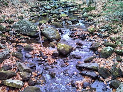
Chapel Brook
beneath the bridge

Chapel Brook Falls
the lower cascades at Chapel Brook Falls (long exposure w/SLR)

Chapel Brook Falls
the lower cascades at Chapel Brook Falls (smartphone exposure)

video of Chapel Brook Falls
soothing...