Well THAT was a fun little novelty run. On Saturday, February 4th I ran in the 15-mile trail race at the annual TARCtic Frozen Yeti event at the Hale Reservation in Westwood, MA, put on by the Trail Animals Running Club (TARC). I say it was novel for a couple of reasons. 1.) The course is wildly complicated, in a way that I love, 2.) the 15-mile race starts at 8 p.m. and runs entirely in the dark, which is unusual to say the least, and 3.) the freakishly cold weather.
After a relatively mild winter so far, a record-setting cold blast polar vortexed its way south into the Northeast and spent 24 hours giving us one of the coldest cold snaps in recent memory, complete with extreme wind chills (especially up on Mt. Washington) and power outages. A house that my brother and I own in Maine lost power for 5 hours and had some pipes freeze in that time (and yes, one did burst). We weren't alone; it seems like Friday night into Saturday was basically a mass pipe-freezing event in the region.
The worst of the weather was from Friday night to Saturday morning, when the 30-hour race started. The people running in that event persevered through incredibly challenging conditions, but you can read about that elsewhere (and you should; look for the story of Brian Burke running 118 miles and breaking the course record, for starters).
I arrived a few hours early, just before sunset on Saturday afternoon, and enjoyed chatting with Russet and Catherine, two of my immediate neighbors inside the lodge, as well as prolific MassUltra scribe Chris Wristen and race directors Surjeet and Josh. I also spent some time eavesdropping on some of the 30-hour runners who were taking breaks inside, listening for any helpful tips (which included "don't OVER-dress, as you'll get too sweaty" and "loop 2 is the most consistently runnable.")
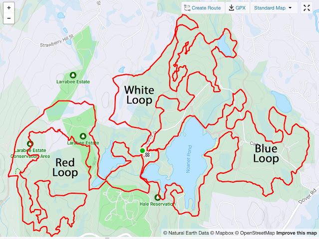
The course is set up like a crazy 3-petaled flower, with each petal loop being roughly a third of the distance. You finish each loop back at the heated lodge in the center of the Hale Reservation where you start. Over 95% of the route is on trails, with more or less equal amounts of singletrack and doubletrack. Temperatures at the start were rebounding from the worst of the cold snap, but it was still only 13 degrees out and pretty much stayed there the whole night.
Let's get right to the play-by-play for the 15-miler:
shivering at the start (photo by Jade Biwa Zhang)
the crazy cool course
Loop 1: The Red Loop
- I started out a little faster than planned, but it was hard not to because the first part is on road and the initial climbing is fairly gentle.
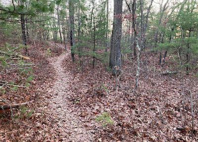
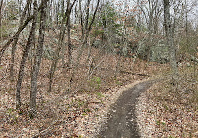
- After the road start, though, the first few miles feature some of the most technical narrow singletrack of the entire course, with lots of hopping up and down and over exposed ledges on Strawberry Hill and Powissett Peak.
- At about mile 3.5, going up and over the rocks of Powissett Peak, I realized I hadn't sipped anything from my hydration pack yet. I'd filled my 1.5-liter Osprey bladder with Gatorade hoping it would take longer to freeze than water, and bought insulation for the drinking tube and bite valve. Well, it had frozen anyway, and never unfroze again (not even the handy tube-thawing station in the lodge would melt its cold, cold heart). I carried 1.5 liters of unobtainable Gatorade around the entire course.
- At about mile 4, a gang of nearby coyotes started howling pretty intensely in the dark off to the left, which was a nice touch.
- At mile 4.5, my watch informed me with a buzz that my iPhone battery was about to die, and sure enough it was completely kaput by the end of the loop; so much for any emergency calls.
Loop 2: The White Loop
- About a mile into this loop I was trailing the blinking red light of a runner about 200 feet ahead of me when I heard some rustling off to my left. I looked over and my headlamp beam reflected off a pair of eyes watching me. I glanced over two more times and they were watching every time.
- Russet passed me under the powerlines. She led a group of women at a steady pace that was just slightly faster than mine and they very slowly pulled ahead of me on the Power Glide singletrack section.
- More so than on other loops, there's places where you come very close to where you were just minutes or in some case miles before, and you could probably say hello to runners ahead of or behind you in the race.
Loop 3: The Blue Loop
- The final loop starts and ends with a very short lollipop stick with two-way traffic, though I didn't encounter anyone going the opposite way either time.
- After running through the woods along the west side of Noanet Pond, you bear right and cross a raised earthen dam on a dirt road.
- Then you bear left and drop down to a really fun "corkscrew" boardwalk. It's basically a hundred feet or so of undulating wooden boardwalk bridge over a marsh; it isn't at all level, and feels like a surrealist's idea of a path. Fortunately it wasn't very slippery.
- Next was a climb up and over a hill called Cat Rock, which I'd remembered had a very steep pitch to navigate on the descent. It wasn't too bad but I slowed there anyway just to be safe.
- From there it was about a mile of relatively easy running over to a pond, up through and down an open field, and up a gentle rise past a residential area off to the left.
- After crossing the park road there's a series of rises and falls through the woods including one fairly significant climb, then you drop down to Cat Rock Field parking (where my car was).
- Around the east and south sides of Noanet Pond, the course includes two beach crossings where you run across open sandy stretches; these were actually fairly easy since the packed sand wasn't too loose underfoot.
- LOTS of rising and falling along the shore of the pond in the second to last mile.
- The final mile was my least favorite stretch, partly because I was fairly beat by then but mostly because it's very rooty and unkempt. I'm pretty tall and there were lots of places where briars dangled into the trail. There were also a LOT of kickable rocks in this stretch, along with a few icy patches. That said, it's still trail, and I do loves me some trail.
- Shout out to the two intrepid young sisters who passed me in the final miles for the shared experience of bringing it all home at the end.



Overall
I finished in 3 hours and 27 minutes, which I was pleased with. It was about right given my training and current fitness level.
Full Results.
Navigation: Zero problems, despite the complexity you see on the map. Arrows and ribbons both featured reflective markings, most of which were easy to see (unless the wind turned a ribbon the other way). The start of the white loop is ever so slightly a challenge to follow from the lodge, so maybe a hair more signage for that might help, but after a few hundred feet past the parking lot it was plenty clear enough. No major trips, stumbles, or falls! Major kudos to the course-marking crew.
Clothing: I wore a windshell jacket over a long-sleeve zip-neck top, shorts over regular ASICS trail tights, lightweight gloves, and a lightweight beanie. It was perfect. I never got too hot and rarely felt very cold. The coldest I felt was when I realized my shirt had come untucked and my lower belly was slightly exposed (tucked shirt back in; problem solved).
Food: PB & J and a beet juice can about an hour before, 2 cups of tailwind and a cookie after each lap, and some hot soup and a quesadilla wedge after. I definitely could have used more hydration, but I did what I could given the frozen bladder tube. Volunteers were also providing a giant bounty of food inside the lodge, but for the most part I felt like the 30-hour runners should get first dibs on all of that (I did have some hot soup, a freshly grilled quesadilla wedge, and a grilled cheese bite afterwards).
In Conclusion: I loved this event and was pleased to be able to tell the course designer Josh Katzman how much I appreciated the design of his race. It was fun to run entirely at night and on trails I enjoy and with such easygoing like-minded members of my tribe.
a very Yeti positive race bib =)
edible medal


