The forecast for this weekend looked daunting, with seasonally chilly temperatures and a possible nor’easter storm on Sunday or
Monday. However, it didn't turn out that bad, and by the middle of this coming week it’s supposed to warm way up again.
In honor of THAT forecast, here is a new bonus site.
As a brief recap of previous bonus site posts: my
guidebook Trail Running Western
Massachusetts (click
here to view the book's page on Amazon) profiles 51 of the best trail
running sites in the region. It was a challenge to whittle down the final list
included in the book to just 51 sites, and some that I really like or that
would have been nice to include had to get cut for space. I occasionally post
profiles of some of those "bonus sites" here and link to them
from the book's Facebook page. (see the Chapel Brook to D.A.R. Trail, Mormon Hollow,
and Ashley Pond posts for previous examples).
Land ownership at this southern end of the Mt. Toby block is a complex puzzle of parcels, some of which
are public conservation land with public access, some of which are private
conservation land with public access, some of which are private land posted
with No Trespassing signs, and some of which are unposted private land. Trail signage is minimal, and restricted to
the trailhead for the Robert Frost Trail and several major junctions along its
route north to Mt. Toby.
There are some fun sections of trail, most notably the Robert Frost Trail as it gradually climbs up and over Bull Hill via Russell Hill from the trailhead at Bull Hill Road. There is also an interesting loop that can be made through The Nature Conservancy’s Greene Swamp Preserve, which
includes two south-facing vistas with great views across the pastoral valley to
the Holyoke Range and Mt. Tom beyond. Part of this loop traverses private land.

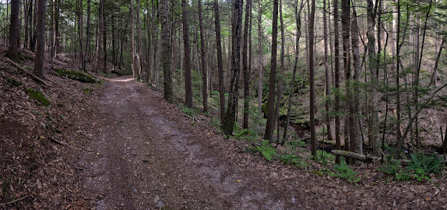 scenic hemlock ravine along Middle Mtn. Road on the west side of Mt. Toby

autumn view from one of the south-facing vistas southwest of Bull Hill and Greene Swamp

To the northwest, several dirt roads lead up from the town of Sunderland and head east
toward Mt. Toby. There are several pretty
stretches, including one notably pretty hemlock ravine, but for the most part
these old roads (Middle Mountain Road and South Mountain Road) are heavily eroded and not particularly nice to run on since
they are too full of loose rocks and wet, sloppy sections to be much fun. Also,
a warren of unmarked trails and old roads weaves in and out of private land,
some of which is distinctly posted No Trespassing. A better bet is to continues
N/NE of the RFT toward Mt. Toby (see site #33 in the book). Note: the RFT
Bypass Trail makes a particularly pleasant alternate option to the part of the
RFT that runs just west of the summit of Roaring Mtn. (also, the hard-to-follow
spur up to the wooded summit of Roaring isn’t really worth it).

Bull Hill (Mt. Toby south) -- Click here for a full-size pdf of the map
Other good nearby trail running sites: Mt. Toby, Puffers Pond and the Eastman Brook Conservation Area, Sugarloaf Mountain, Pocumtuck Ridge
If you have any comments, complaints, corrections, praise, or suggestions about this bonus site or anything related to Trail Running Western Massachusetts, please comment below or drop me an email with your thoughts!
If you have any comments, complaints, corrections, praise, or suggestions about this bonus site or anything related to Trail Running Western Massachusetts, please comment below or drop me an email with your thoughts!
No comments:
Post a Comment