"Don't go out too fast," warned a race director.
"It's pretty flat to begin with, but around mile 7 or so you hit some kettles with short but steep hills that you'll want to save for." He was referring to a series of wetland depressions in the otherwise well-drained upland landscape, and his advice was sound. The hills hit hard and fast, and they definitely required quick surges of energy to power up.
With 3 weeks to go until my A-race, the Stone Cat Trail Marathon, I wanted to run a mid-distance "tune up" trail race that would serve as a 20-miler (when combined with generous warm-up and cool down runs), and not be too hilly. The long course (9.5 miles) at the annual Groton Town Forest Trail Races fit the bill. The alternative that day was the 14-mile Mt. Toby Trail Run, which is much closer to home but has that very significant thousand feet or so of race climbing to need to recover from afterwards. So early Sunday morning I headed east for Groton.
Race day was chilly and raw, especially on the heels of the previous weekend at Monroe, which had been amazingly warm and pleasant. It felt like late fall, maybe even early winter. I still wore shorts and a t-shirt (long-sleeve) for the actual race, but I was right on the edge of being too cold.
The race starts along an old rail bed at the northern edge of the forest, about a quarter mile south of parking and registration at a town senior center. The first mile follows a flat, straight stretch on dirt road. It was leaf-covered, but otherwise bore little resemblance to the rest of the course in terms of terrain and forest type. It crossed and re-crossed some live(?) rail tracks, then veered onto a winding singletrack path. From there, the course followed a mix of singletrack, doubletrack, and woods roads through the oak and pine forest. Except for a few rough eroded parts (usually on short, steep hills), it was great for running.
I started out slightly optimistic, hanging out somewhere around 10th place for a while, but eventually I got passed by a pack of people I couldn't quite seem to keep up with. They disappeared from my sight at the first water stop, where I lost some time fumbling to tear open a gel packet. After that I mostly found myself running alone, except for one guy who slowly reeled me in.
The sinuous singletrack portions, clearly designed with mountain bikers in mind, made for fantastic trail running tracks. They curved organically back and forth across the dry hilltops and roller-coastered up and down steeper slopes, generally making excellent use of the natural terrain. A few sections right along the Nashua River were pretty scenic too.
By the time I got to them about 2/3 of the way through the race, the kettle hills that I'd been warned about, along with some associated eskers and side ridges, definitely felt like obstacles in the path that took some wind out of my sails. I wasn't exactly well-rested for this race, as it fell at the tail end of one of my highest mileage weeks in ages. But they were fun nevertheless, and I only got passed by one person in that section.
The final mile was mostly flat, and ended back at the start. I finished in 1:16:20 (full results here), which comes out as just a few seconds over 8-minute miles. I felt pleased with my time and effort, and, most importantly, gained an extra boost of confidence for Stone Cat.
Sunday, October 18, 2015

Thursday, October 15, 2015
Finding Negus
For years I'd been hearing whispers of a neat trail on a peak called Mt. Negus (a.k.a., Negus Mountain, pronounced "knee-gus") in the Zoar region of northwestern Massachusetts, just north of and across the Deerfield River from Mohawk Trail State Forest. But I couldn't find much information about it. It wasn't in any hiking guidebooks and it didn't show up on any maps and there didn't seem to be any official trailhead. I couldn't even find much on the internet. Eventually, though, I pieced enough together to figure out where to park and where to start walking. And naturally it really wasn't all that hard to find once I knew where to look and where to go.


Great Stuff Nearby: Mohawk Trail State Forest just to the south across the river; Monroe State Forest (with Spruce Peak, Raycroft Lookout, and Dunbar Brook) a few miles to the north; the little-known gem of Pelham Lake Park a few miles northeast in Rowe; and the Deerfield River Trails network (formerly Charlemont Trails) and Thunder Mountain Bike Park at Berkshire East.
Parking is along a short section of paved road on the right side of Zoar Road immediately before it crosses the Deerfield River and becomes River Road. Elevation here is about 750 ft. You walk down the road until you reach a yellow metal gate just before the railroad tracks, at which point you should see the trail start into the woods on the other side of the tracks. It has recently been blazed with blue paint markers, and there are occasional round white signs with a blue bear paw symbol saying "Bear Swamp Hiking Trail -- Brookfield."

the trail at Mt. Negus
The trail is steep right off the bat. Really steep. Really, really steep. As in, you gain hundreds of feet of elevation in the first quarter mile or so. That said, it's not so steep that it requires ladders or rungs or ropes or anything. But you'll probably need to use your hands to scale some of the rocky ledges, especially while the trail is still down in the woods. When I hiked it, I was scouting to see if the trail could be used for trail running, and my general assessment is that I think it would be just over the edge of being too dangerous and probably not all that much fun to run, especially if the rocks were at all wet or icy, or if they were covered in leaves. The day I did it was dry and the colorful autumn leaves were mostly still on the trees, but I still wouldn't have wanted to run it.

the trail up the southwest ridge of Mt. Negus is very steep to start with
Before long, the trail emerges out into the open along the narrow spine of the mountain's southwest ridge. Just past a large boulder perched right out in the open on the crest, it swings slightly right and climbs the semi-open ridge to the first peak. This section is remarkably dramatic and scenic, feeling much more like a wild White Mountains trek than most places I've been to in Massachusetts.

dramatic scenery along the semi-open ridge of Mt. Negus
Just before the first peak, the grade lessens slightly and you get some views of the reservoir to the north. At this point you realize that the mountain is really less of a peak than the edge of a broad upland plateau covering much of this far corner of the state, and that over time the Deerfield River has carved a pretty deep, now-wooded canyon out of it. Then the trail crosses over the wooded knob and makes its way north towards the actual summit.
For the record, the next quarter mile or so of trail IS quite enjoyably runnable, as it gently meanders through the woods between the two peaks. Then it comes out at an old jeep road just west of the higher summit (which it does not cross). The road ends at a bulb here, and there is a limited view to the west, but the better summit was definitely the first one. From the bulb, the rough road descends towards Steele Brook Rd / Tunnel Road and the reservoir to the north. This was where I turned around.

bony ledges partway along the narrow ridge of Mt. Negus

a far-reaching view that feels as wild and remote as anywhere I've seen in this state.
Overall it's really not a very long hike, hardly 2.5 miles round-trip. But it's challenging, especially in that first quarter mile or so near the bottom, with about 1,000 ft. of elevation gain in total. And it is exposed, and could be cold and/or tricky when it's windy or stormy out. On the day I did it, however, the afternoon sun warmed the ridge exquisitely, and there was a light breeze, so I just took my time and snapped some photos and sat in various spots along the way and admired the view. I've since heard that my friend Jeff incorporated it into a longer run that started at Mohawk Trail State Forest, which sounds like such a fun trip. All of the trails are on the scannable QR code map for site #8 in Trail Running Western Massachusetts.

map of Negus Mountain
Great Stuff Nearby: Mohawk Trail State Forest just to the south across the river; Monroe State Forest (with Spruce Peak, Raycroft Lookout, and Dunbar Brook) a few miles to the north; the little-known gem of Pelham Lake Park a few miles northeast in Rowe; and the Deerfield River Trails network (formerly Charlemont Trails) and Thunder Mountain Bike Park at Berkshire East.
Sunday, October 11, 2015
2015 Monroe Dunbar Brook Trail Race
For the past two years, I've taken photos of racers crossing the stream at mile 9.5 of the Monroe Dunbar Book Trail Race (see galleries for 2013 and 2014). I love the splashy drama and they're some of my favorite photos, but this year jealousy got the better of me and I decided to run it again. I couldn't have chosen a better year.
The weather was simply perfect: sunny, warm but not hot, low humidity, and a light breeze. The late arrival of fall this year meant that there were far fewer leaves covering the trail than usual, resulting in a much easier experience finding footing along the way.


I've thoroughly described the course in site 6 of my guidebook Trail Running Western Massachusetts, and blogged about the race in the past (see post here), so I won't repeat any of that information here. As for my race this year? Awesome. I felt great throughout, and I beat my 2012 time by more than 2 minutes.
There was one incident that hobbled me a bit, however. I tried a different (new) pair of socks in my ASICS Fuji Racers, and it turned out to be just as stupid a thing to do as they always tell you it will be. The socks slipped down my heels in both shoes, resulting in an uncomfortable, almost certainly blister-producing scenario. So, on the summit ridge, about halfway up from the powerlines to the top, I stopped and sat on a fallen log and removed both shoes to fix things. Untying and retying double knots and taking the shoes off and pulling socks up probably cost me a minimum of two minutes, which is kind of a lot in a race like this.
Otherwise, I couldn't have hoped for better. I finished in 1:45:40, which was good for 19th place.

Jen ran the race too, and was delighted to defeat the weird asthma demon that had been dogging her ever since late May. She finished in 2:10. At the finish, where there was a great picnic barbeque hosted by the awesomely relaxed and low-key Western Massachusetts Athletic Club (WMAC), we chatted with various friends who had run, including Nate Davis, Dave Stauffer, Arron Stone, Tim Mahoney, Benn Griffin, Rob Higley, and others. And after that Jen and I found our way down the steep slope behind the picnic area and sat on a sunny boulder next to the Dryway section of the Deerfield River for about an hour and watched kayakers and rafters shoot the rapids (Dragon's Tooth, I think) about six feet below us.
I realize it sounds somewhat overblown to say so, but all in all, the 2015 Monroe Dunbar race experience almost perfectly captured the spirit and essence of everything that I love about trail running.
The weather was simply perfect: sunny, warm but not hot, low humidity, and a light breeze. The late arrival of fall this year meant that there were far fewer leaves covering the trail than usual, resulting in a much easier experience finding footing along the way.


L: early climbing at Monroe. R: singletrack path at Monroe.
I've thoroughly described the course in site 6 of my guidebook Trail Running Western Massachusetts, and blogged about the race in the past (see post here), so I won't repeat any of that information here. As for my race this year? Awesome. I felt great throughout, and I beat my 2012 time by more than 2 minutes.
There was one incident that hobbled me a bit, however. I tried a different (new) pair of socks in my ASICS Fuji Racers, and it turned out to be just as stupid a thing to do as they always tell you it will be. The socks slipped down my heels in both shoes, resulting in an uncomfortable, almost certainly blister-producing scenario. So, on the summit ridge, about halfway up from the powerlines to the top, I stopped and sat on a fallen log and removed both shoes to fix things. Untying and retying double knots and taking the shoes off and pulling socks up probably cost me a minimum of two minutes, which is kind of a lot in a race like this.
Otherwise, I couldn't have hoped for better. I finished in 1:45:40, which was good for 19th place.

me crossing Dunbar Brook at Monroe
Jen ran the race too, and was delighted to defeat the weird asthma demon that had been dogging her ever since late May. She finished in 2:10. At the finish, where there was a great picnic barbeque hosted by the awesomely relaxed and low-key Western Massachusetts Athletic Club (WMAC), we chatted with various friends who had run, including Nate Davis, Dave Stauffer, Arron Stone, Tim Mahoney, Benn Griffin, Rob Higley, and others. And after that Jen and I found our way down the steep slope behind the picnic area and sat on a sunny boulder next to the Dryway section of the Deerfield River for about an hour and watched kayakers and rafters shoot the rapids (Dragon's Tooth, I think) about six feet below us.
I realize it sounds somewhat overblown to say so, but all in all, the 2015 Monroe Dunbar race experience almost perfectly captured the spirit and essence of everything that I love about trail running.
Wednesday, September 30, 2015
Leaving Williamsburg

Williamsburg, MA
Today, after just over 2 years of living in Williamsburg, we're leaving the hilltowns and lighting out for lure of Greenfield. The new place is only about half an hour farther north in the Pioneer Valley, but it makes a lot more sense for our commutes. We will definitely miss the charms of being right in the rural village (easy walks to the The Brewmaster's Tavern, Cichy's Garage, and Meekins Library; very short drives to Elbow Room Coffee, Bread Euphoria, and the Local Burger food truck; and the excellent Joe's Garage bike shop in Haydenville). And I will definitely miss both my regular running routes (the 3.5-mile loop around Depot Rd / O'Neil Rd, the 6.2-mile loop up North Rd and Hememway and back Village Hill, and out-and-backs up Nash Hill Rd) and the trails slightly further afield (DAR State Forest, Chapel Brook Falls to Bullitt Reservation, and Chesterfield Gorge, among others). I'll also miss some of the shorter trails maintained by Williamsburg Woodland Trails, like Petticoat Hill and the one pictured below at the Breckenridge Sanctuary.

trail running at the Breckenridge Sanctuary
Farewell Williamsburg!
[10/10/15 update]: And hello, Greenfield! So far, we're loving the food (Mesa Verde, The People's Pint, The Brass Buckle, Magpie's, Hope & Olive, The Rendezvous over in Turner's, etc.), the trail runs (Greenfield Ridge, Catamount State Forest just to the west, etc.), and the general lively vibe of a seemingly thriving downtown (Green Fields Market, World Eye Books, and Wilson's come to mind). We're hoping to make it a good stay.
Monday, September 21, 2015
2015 Pisgah Trail Races
I have a love / love relationship with the Pisgah Mountain Trail Races. On one hand, I love the short course 14-miler (23K). On the other hand, I love the long course 50K. And I love the terrain and trails and pretty much everything about the whole thing. So... yeah. It's basically a big love-fest for me.
My first time running the 23K was in 2005, when I finished it in 2:28:21. It was my first experience racing that kind of distance on those kinds of trails, and although I enjoyed it, it seemed like more of a novelty at the time. I was trying to get back into road marathons and felt like running trails were waiting to mess me up somehow. Not that I didn't hike all the time, or regularly run trails over shorter distances. It just wasn't where I was at. Anyway, a few years later, I returned to Pisgah for work and created an interpretive trail guide that partly overlaps with trails used in the race. In 2012 I ran it again, this time clobbering my time with a 2:15:43 finish. I wrote about that in an earlier blog post. Then in 2013 I went back yet again and did the 50K as my first ultra, and wrote about that race extensively here. And lastly, I went back one more time, in 2014, and took photos of racers in both events, and posted a blog entry about that here.
This year I decided to run the 23K again, partly as part of a build-up to the Stone Cat Trail Marathon in early November and partly just for the fun of it. I've been trying to determine whether my Achilles is going to let me continue or not, as it's been very tight lately. It seems like I'm juuust able to get by "managing" it, but I suspect I'll need to take some time off soon. Anyway, I didn't think I was fit enough or fast enough to get a PR this year, but I was feeling decent and hoped that I'd at least come close.
The weather couldn't have been more perfect. Ideal temps, not too humid, and after a week where it only rained once so you knew that it wouldn't be too slick or muddy out there. At the start it was hard to not go out faster. I wanted to, but I also really wanted to make sure I didn't overstress my achilles. So I settled into a sensible pace out the dirt road to the start of the woods roads and doubletrack. And once I entered the woods and watched some 50K runners peel off to the left, I ran alone for quite a while. Knowing the course and park well, I was never afraid that I was lost or had taken a wrong turn, but it is amazing how there always seems to be a stretch or two where I see a wetland off to the side that I don't remember at all.
I reached the Reservoir water station and passed a handful of runners who slowed to take a longer break there. One of them re-passed me on the long singletrack grind going up the mountain, but otherwise I never saw the others again. The numerous false summits of Mt. Pisgah fooled me yet again, as I thought for sure I was near the final peak when there was still one more to go (following yet another dip down to a saddle in the woods). Flying down the far side, I was really glad to know the trail well, and even gladder that it wasn't slippery this year. Just before bottoming out I passed Fred Ross who took an awesome photo of me starting to leap over a log that had fallen across the trail.

My first time running the 23K was in 2005, when I finished it in 2:28:21. It was my first experience racing that kind of distance on those kinds of trails, and although I enjoyed it, it seemed like more of a novelty at the time. I was trying to get back into road marathons and felt like running trails were waiting to mess me up somehow. Not that I didn't hike all the time, or regularly run trails over shorter distances. It just wasn't where I was at. Anyway, a few years later, I returned to Pisgah for work and created an interpretive trail guide that partly overlaps with trails used in the race. In 2012 I ran it again, this time clobbering my time with a 2:15:43 finish. I wrote about that in an earlier blog post. Then in 2013 I went back yet again and did the 50K as my first ultra, and wrote about that race extensively here. And lastly, I went back one more time, in 2014, and took photos of racers in both events, and posted a blog entry about that here.
This year I decided to run the 23K again, partly as part of a build-up to the Stone Cat Trail Marathon in early November and partly just for the fun of it. I've been trying to determine whether my Achilles is going to let me continue or not, as it's been very tight lately. It seems like I'm juuust able to get by "managing" it, but I suspect I'll need to take some time off soon. Anyway, I didn't think I was fit enough or fast enough to get a PR this year, but I was feeling decent and hoped that I'd at least come close.
The weather couldn't have been more perfect. Ideal temps, not too humid, and after a week where it only rained once so you knew that it wouldn't be too slick or muddy out there. At the start it was hard to not go out faster. I wanted to, but I also really wanted to make sure I didn't overstress my achilles. So I settled into a sensible pace out the dirt road to the start of the woods roads and doubletrack. And once I entered the woods and watched some 50K runners peel off to the left, I ran alone for quite a while. Knowing the course and park well, I was never afraid that I was lost or had taken a wrong turn, but it is amazing how there always seems to be a stretch or two where I see a wetland off to the side that I don't remember at all.
I reached the Reservoir water station and passed a handful of runners who slowed to take a longer break there. One of them re-passed me on the long singletrack grind going up the mountain, but otherwise I never saw the others again. The numerous false summits of Mt. Pisgah fooled me yet again, as I thought for sure I was near the final peak when there was still one more to go (following yet another dip down to a saddle in the woods). Flying down the far side, I was really glad to know the trail well, and even gladder that it wasn't slippery this year. Just before bottoming out I passed Fred Ross who took an awesome photo of me starting to leap over a log that had fallen across the trail.

killer leap photo by the ever-intrepid Fred Ross
After the nearly mile-long (hilly) dirt road section, the final miles up and over the wooded summits of Davis Hill and Hubbard Hill flew by without too much of note, save for one dumb-ass moment. About a quarter mile up from the gate at the bottom of the last descent, I violently rolled an ankle out and fell down hard. Cursing, I got up slowly and hobbled along for a few steps trying to see if I could move. It hurt quite a bit and I thought for sure I'd sprained it yet again. But amazingly enough, after about 2 minutes the pain subsided and I was able to start running again, slowly at first and then closer to my original pace a few minutes later. I finished in 2:19:45, four minutes slower than 3 years ago, and about nine minutes faster than 2005.
After finishing, I went back out onto the course to take photos of the 50K runners around mile 29-30 of their race. All of those pictures are in a gallery here.
Sunday, August 30, 2015
Trail Running Acadia
Mount Desert Island in Maine is a true runner’s paradise. With all the carriage trails and hiking trails of Acadia National Park, the many adjacent town trails that connect to them, and miles of less-travelled back roads and side paths, there really is something for everyone, with all kinds of scenery types and at every skill level.
I was lucky enough to grow up on the island, where I developed lasting loves both of the trails and of running. By the time I graduated from high school, I had run or hiked every existing mile of trail or carriage trail that I knew of (I had an AMC map with every last trail line colored orange). My mother still lives there and I try to get back once or twice a year, though often those visits are far too short.
This summer, Jen and I set aside a full week and made a legitimate vacation out of it. Our visit came on the heels of several very exhausting (yet excellent) days in the White Mountains (see separate post here), and also it was the hottest week of the summer, so our outdoor adventure days were interspersed with low-key rest and relaxation days.


lounging at the Blagden Preserve on the island's quiet side
After spending a day basking by the shore far away from the crowds at The Nature Conservancy’s Blagden Preserve in Somesville, we dipped our toes in the carriage trail waters by running the 4-mile Witch Hole Pond / Paradise Hill loop from Duck Brook Bridge. As always on the carriage trails, the running was fairly mellow despite the rolling hills. The soft dirt roadbed is easy on the body, and the occasional scenic views are definitely easy on the soul. We ran slow and steady, shaking some of the White-Mountains-induced soreness out of our legs. Then we soaked our feet in the amazingly warm stream below the bridge afterwards, and were amazed that there wasn’t a single mosquito or blackfly to tarnish the moment.
The first classic singletrack trail run we did was a short 4-mile loop up and over Cedar Swamp Mountain. Starting at the Gate House parking area just up the hill from Northeast Harbor, we followed the Upper Hadlock Carriage Road north to the waterfall bridge, where we then started hiking up the rooty Hadlock Brook Trail. I was very pleased to see that the rootiest section of trail I know of anywhere is currently receiving a much-needed makeover. Trail crews are hard at work creating a new switchback near the junction with the trail (that we took) leading south up to Birch Spring. At Birch Spring we took a right and climbed the last little steep pitch to the summit of Cedar Swamp Mtn. After enjoying the late afternoon views, we headed off for the very fun mile and a half or so descent down the south ridge. The footing alternates between bony granite ledge and soft, conifer needle coated forest duff, and we couldn’t keep ourselves from letting out little whoops and whees as we darted down the mountain and enjoyed occasional unnecessary springs off of boulders. At the bottom, we closed the loop with a short jog back along the Amphitheater Carriage Trail to the Gate House. This run was of course followed up by a refreshing swim in Echo Lake.


The next classic trail run involved the Cadillac South Ridge Trail. The day was warm and sunny to start, but we could tell that a persistent sea breeze was beginning to bring in some fog from over the ocean. Copying a really fun route my brother and I had devised a few years earlier, we left a car along Rte. 3 near Blackwoods Campground and had my mother shuttle us north up the road a few miles to just south of the Tarn. From the trailhead, the trail drops gently down the slope for a few tenths of a mile to a set of wooden bridges along a beaver dam and then connects with the Tarn Trail. Taking a left at that junction, we followed the flat (and recently well-renovated) Tarn Trail south for a mile or so. After beginning to climb, then curving right and passing junctions with the Dorr South Ridge and Canon Brook Trails, we started north up the mostly runnable A. Murray Young Path, which offers an excellent example of the frequently magnificent stonework along trails in Acadia. Well-placed rocks guide the way and provide amazingly flat footing as you slowly rise up the slope of the gorge between Cadillac and Dorr. Eventually you need to climb a short open talus section just south of the top of the saddle between the two mountains, but it’s always easily navigable (though it does help to use your hands in a few places). At the open area, we could see the fog beginning to surge in fast from the south.


Trail running Cedar Swamp Mountain

fog rolling in
From the saddle, it’s a very strenuous 4-mile ascent up to the summit of Cadillac Mountain and all of its hoards of people. I wanted to buy a Snickers bar or something in the gift shop, but I swear the product selection in there is just about the worst I’ve ever seen. And no Snickers bars. Don’t tell me this was some attempt to offer healthy snacks to visitors, because I saw a lot of garbage for sale in there. Just… ugh. I started to get antsy in there right away and we just left and hit the trail again.

surging over the summit
To reach the South Ridge Trail, and the highlight of the run, we followed the trail across the forested part of the summit to the open section near the Beech Hill overlook and the West Face Trail. From there, the next mile is simply glorious. Heading due south, the trail gently descends the wide-open granite ridgeline, offering a sort of natural pavement that feels like a real runner’s playground. It’s impossible to not catch yourself grinning and feeling extra bursts of energy. The fog had begun to sweep in over us, but on a clear day there are views far out to sea over the outer islands. After a steep drop down to a small saddle with a wetland called The Featherbed, the trail briefly rises again over a section of rugged ledge and then continues descending gently again, this time along the now slightly more vegetated but still semi-open ridge. If anything, this section is even more runnable than the previous one. Parts of it feel like a roller coaster and others remind me of carving soft turns while downhill skiing. After passing the Eagles Crag spur trail, it becomes fully forested and there are some rocks and roots to contend with, but time passed quickly and before we knew it we’d arrived back at our car.


running down the Cadillac South Ridge Trail
Our final trail run was a complex loop at Beech Cliffs and Beech Mountain that included running south along the Valley Trail and north up the well-switchbacked South Ridge Trail. The final push to the summit is steep and demanding, but the views northwest out over Long Pond near the end of this run are always breathtaking.


Beech Mountain vista panorama
We were very pleased with the routes we ran, but there are many other great ones out there (see map of the island here). Some fun routes to consider for trail running adventures on the island include: Pemetic Mountain (especially the south ridge), all trails on Sargent Mtn. (especially the South Ridge Trail and the one that passes by the swimmable Sargent Mtn. Pond), Penobscot Mountain, the North Ridge of Dorr Mtn., Champlain to the Beehive and Gorham, Western Mountain, the Asticou Trail, and the Around Mountain Carriage Trail, among others. You see the pattern here. Basically, any trail that trends north-south along a ridge on the island is fantastic for running (the ones through gorges and ravines are very scenic but not always as runnable so you need to choose wisely there).


a foggy carriage trail along Bubble Pond
Numerous guidebooks and websites have been written about the trails; two of my favorites are Tom St. Germain’s A Walk in the Park (Tom is an avid trail runner and skilled old trail finder) and Joe’s Guide to Acadia National Park by Joe Braun (he has some really fantastic photos too). The island is also home to a host of fantastic annual races, including the Northeast Harbor 5-Mile Road Race, the Bar Harbor Half-Marathon, and the Mount Desert Island Marathon.
Saturday, August 29, 2015
Two White Mountain Treks
It feels like the White Mountains are constantly calling me back. Since I've lived in western Massachusetts, various circumstances have kept from from making the trip up (plus I've just genuinely enjoyed exploring and writing about new places around here), but this past week Jen and I got up there for two excellent days of mountain trekking as an active prelude at the start of a vacation that consisted mostly of a trip home to Mount Desert Island.

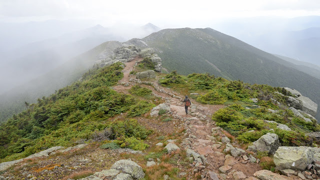




On the first day we hiked the classic 9-mile Franconia Ridge loop. We did it clockwise to give ourselves the hut on the way up and to give me a chance to soak my aching achilles in Dry Brook along the Falling Waters Trail on the way down. The weather generally cooperated, though the ridge was frequently in-and-out of the clouds every few minutes, and it did rain on us briefly somewhere just before the summit of Mt. Lincoln. Some photos from that day:


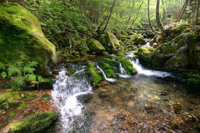
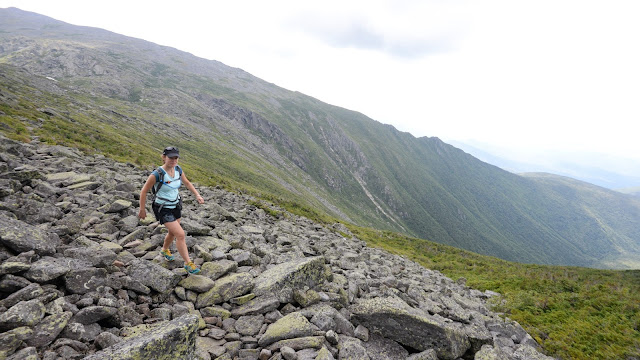
On the second day we took advantage of stellar weather and headed for the Presidential Range. Back in 2006 I'd really enjoyed a hike with Pete and Doug going up Mt. Jefferson via the very remote, scenic, and challenging Castle Ravine Trail, and wanted to show Jen some of that coolness. We set out in running shoes with as minimal an amount of gear as we thought was safe, and headed up. There are about a dozen mandatory stream crossings on the route, and we chose to just splash right on through each one. This saved us time and allowed us to cool off each time. I even began to take my time at each crossing to enjoy the cold water even more. The ravine gets wilder and wilder as you go, eventually culminating in a brief foray through a mossy cold-air talus forest at the base of the headwall, where refrigerated air whooshes up out of dark spaces in the boulders below. That's followed by a very demanding climb up an occasionally loose open talus slope to Edmands Col between Mt. Jefferson and Mt. Adams. After that we descended via the Israel Ridge Path, grabbed a sunset dinner at a brewery tavern near Sunday River, then drove east to Mount Desert Island. Some photos from that day:

idyllic cascades along Castle Brook

deep in Castle Ravine

climbing Castle Ravine

at Edmands Col

skyrunning
Bonus Site: Kennedy Park to Yokun Ridge Connector
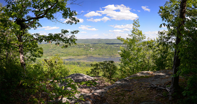
Two fantastic sites profiled in Trail Running Western Massachusetts, Kennedy Park (site #13) and Yokun Ridge (site #14), are actually linked by a network of unofficial trails. The trails cross private land, and as a result this area could not be described or mapped in the book. They are clearly well-maintained and regularly used, however, and make for very pleasant if somewhat challenging running. To stay clear of any potential trespass issues, it is probably safest to stick to the northernmost trails of the network. These trails can be run on their own, as extensions of the sites on either side, or as a link between the two sites as part of a very fun and varied long run.

site map

stunning eastward view from an unnamed ledge on the eastern side of Yokun Ridge
Trail tidbits:
-Most of the trails are pretty easy to follow (though it can be somewhat hard to initially find them, especially on the eastern Kennedy Park side)
-These trails meander and switchback around a LOT, and it can take longer to get from point A to point B than you might expect
-Always obey any posted signs you many encounter
Friday, August 7, 2015
Bonus Site: Mormon Hollow at Wendell State Forest
My new guidebook Trail Running Western Massachusetts (click here to view the book's page on Amazon) profiles 51 of the best trail running sites in the region. It was a challenge to whittle the final list to be included in the book down to just 51 sites, and some sites that I really like or that would have been nice to include had to be cut for space. I occasionally post profiles of some of those "bonus sites" here and link to them from the book's Facebook page. (see the Chapel Brook to D.A.R. Trail post for a previous example).
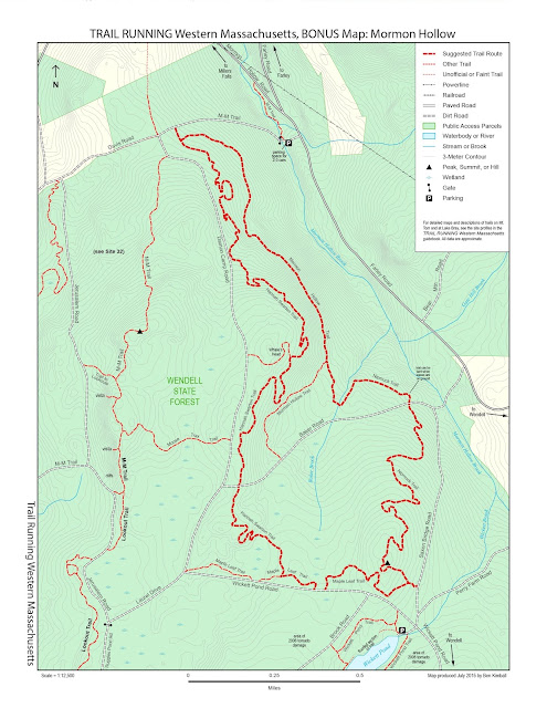
In this case, the bonus site is a second sweet loop option at Wendell State Forest. The one profiled in the book, as Site #32, is a fantastic run that begins and ends in the Ruggles Pond / Park HQ area of the property. This loop is located just to the northeast, and can be accessed either from below at a small, very inconspicuous parking spot near the east end of Davis Road off of Farley Road, or from a more prominent (though not much larger) parking area by the boat launch at the north end of Wickett Pond. Beware that Wickett Pond Road can be extremely muddy in spring.
The loop combines portions of four trails: the Mormon Hollow Trail, the Nipmuck Trail (not to be confused with the one in northeastern CT where the Nipmuck Trail Marathon takes place), the Maple Leaf Trail, and the Hannah Swarton Trail. The running is really good on all of them. There's a lot of swooping and curving and climbing/descending on switchbacks. The loop can be run just as easily in either direction and from either end, though the Nipmuck Trail portion is probably more fun to descend. There is one section of the Nipmuck Trail, just north of Baker Road, that can be a bit challenging to follow in late fall or early spring when the leaves are down, but it's much easier in summer. While there are no scenic vistas along the completely forested route, short side trips can take you to Wickett Pond and Whale's Head, a large boulder just uphill from the trail.
site map
 |
| Hannah Swarton Trail at Davis Road |
 |
| Whale's Head at Wendell State Forest |
 |
| Maple Leaf Trail along the edge of a wetland at Wendell State Forest |
If you have any comments, complaints, corrections, praise, or suggestions about this bonus site or anything related to the Trail Running Western Massachusetts guidebook, please comment below or drop me an email with your thoughts!